Thursday, May 31, 2012

5. Peter Puget's Exploration Party


Captain Vancouver wrote the following orders for this Expedition:

“On 20 May 1792 at 0400 hrs Lt Peter Puget, you are to disembark the HMS Discovery in the launch  and in the cutter, Mr. Whidbey, Sailing Master, whose orders you are to follow. You are to proceed  south keeping “the continental shore to starboard” at 3 days, should it appear to you that you are unable to finally determine its limits, and return to the ship by Thursday next and report to me an account of your proceedings, as to appearance of the country, its productions and inhabitants, if varying from what we have already seen. In search of the northwest passage linking the Atlantic to the Pacific.” Peter Puget's Journal: Blumenthal, Richard, editor of With Vancouver in Inland Washington Waters.

Captain Vancouver, Lt. Puget and Mr.Whidbey had sailed together in Jamaica prior to this voyage and Vancouver had hand picked this special crew: Lt. Peter Puget was 27 or 28 years old, but had been to sea since age 12 or 13, so had 24 years of naval experience under his belt. While being born in England, his ancestors were French Huguenots, who had fled during the Spanish inquisition. He was admired by his Naval superiors and highly respected by his troops. Puget achieved the rank of Rear Admiral in 1821 and died in 1822. After Lt. Puget’s exploration of the southern waters from 20-27 May 1792, Captain Vancouver named the southern waters, Puget’s Sound. 

Joseph Whidbey
Mr. Joseph Whidbey, also, near Puget’s age, was an experienced Sailing Master. [ I wondered why there were no available Journals written by Mr. Whidbey. My conversation with Richard Blumenthal, author of, With Vancouver in Inland Washington Waters, 24 Feb 2012,  states, “while Whidbey was not an Officer in the Royal Navy, he was not required to keep a journal. All the officers had to write and turn in their journals to Vancouver at the end of each exploration”]. Mr. Whidbey, while not an officer, was a member of the British Navy and retired in 1805. Captain Vancouver named Whidbey Island  for him, after he and Lt. Puget circumnavigated the island in June 1792.


Archibald Menzies, botanist and ship’s surgeon was Scottish and attended the University of  Edinburgh. He was the oldest member of the Lt. Puget’s exploration at the age of 38.
Archibald Menzies

He is noted for: 
1. Identified and named the beautifully red-barked Madrona tree for himself, arbutus menziesii, which he found on Protection Island in the Strait of Juan de Fuca. 

2. Identified and named the Douglas Fir after himself,  pseudotsuga menziesii.

3. Was the first non-native to climb the Hawaiian Volcano, Mauna Loa using the native, Ainopo Trail, which today is know as Menzies Trail.

4. To frequently concoct “spruce beer” to be drunk with the daily ration of rum. Some historians conclude this is the reason the HMS Discovery crew never suffered from Scurvy.

He often tried to learn the different languages of the Indian tribes in order  to communicate with them. He graduated from the University of Aberdeen in 1799 with a Degree in Medicine. He retired from the Royal Navy in 1802 and continued practicing medicine in England.

3rd Lt Thomas Manby, age 26, had gained much experience on board and Captain Vancouver had appointed him to 3rd Lt. He kept 2 journals, a personal one and one that he turned into Captain Vancouver.  He lived to achieve the rank of Rear Admiral, however died from an opium overdose in 1825. He loved to hunt and had a favorite double barreled gun that his good friend the Marquis Townshend had given him.

Photos from Google Images

6. The Launches


The 20 foot launch was clinker built and carried 5 pair of oarsmen, seating 2 abreast. There were 2 dismountable masts with lug sails. The other was an 18 foot cutter carrying 3 pair of oarsmen  and a single mast. Both boats were open. Both vessels had swivel guns attached.

A modern day example of  a launch with 5 paired oarsmen.
Google Images


Mr. Whidbey and Lt. Manby traveled in the cutter and Lt. Puget and Mr. Menzies went  in the launch, along with the oarsmen, which totaled 20 men. They would carry enough supplies, ammunition and food/drink, trinkets and gifts for one week. Sam McKinney, in his book, Sailing With Vancouver, stated the food was prepared in England and was made up of wheat, dried soup and spirits, vegetables, and internal oxen organs. This mixture was boiled, then dried and cut into slabs. I can see why they might like to choose eating crow, as that actually sounds better to me. Every sailor was given a ration of rum/day which was 1/2 pint. This was mixed with a quart of water to make grog and given to the sailors twice a day. Since each master ship carried 100 men that would mean there would have to be a lot of rum on board each ship. To put this into perspective a friend calculated the results: 2281 gallons /year for each ship, 9125 gallons for the 4 year expedition, 253 kegs per ship at 38 gal/keg. That, my friends, is a lot of rum. I have trouble finding room for 4 rolls of paper towels and 4 roles of toilet paper.

Preparations were underway as the HMS Discovery sailed south reaching the southern tip of  Restoration Point( named by Vancouver) on Bainbridge Island. Lat 47° 35 N, Long 122°28 W.  At about 6 PM-1800hrs the HMS Discovery anchored somewhere south of Restoration Point and near a small, rounded island, Blake Island, in 35 fathoms of water. After the HMS Discovery anchored, Lt. Puget and Mr. Whidbey quickly departed in their small boats to explore the Indian village. They returned to the HMS Discovery and prepared for their early morning departure.

Another important and interesting thing to note at this time is, the Bainbridge Island--Restoration Point Indian Village was inhabited by the Suquamish tribe of about 80 Indians  and under Chief Schweabe. His 12 year old son, Si’ahls, becomes Chief Se’alth, from which the city of Seattle, Washington is named. Later in life, he recalled seeing Captain Vancouver and the HMS Discovery. Captain Vancouver stated in his report that this Indian village was the most miserable village he had seen. 
Chief Se'alth
Google Images


Confusion has a tight grip on my beginning research. I have often wondered where this pivotal anchorage was located and I was hoping to find its latitude/longitude in the journals of the explorers, at which time I could begin my own, upcoming journey from the exact starting point.
Blake Island
 Google Images 


After reading numerous journals, books, websites and speaking with author/editor- Richard Blumenthal, With Vancouver in Inland Washington Waters, I do not know, nor does he, the exact location of their anchorage. He believes the anchorage was about half way between Restoration Point and Blake Island. In his own replication cruise of Peter Puget’s Exploration, he chose to leave from one of the Washington State Marine buoys north of Blake Island. Based on different renderings, it appears to me, that they are anchored south of Restoration Point and about 2 miles from the northern shore with the small island located off their port. Mr. Menzies clearly states they are anchored close to the inner point of it-- the round island(Blake) western tip and in 35 fathoms of water.

This position is different from what course I extracted from Peter Puget by Robert Wing and Gordon Newell where they have them anchored off Restoration Point  placing their departing course east of Blake Island or taking Blake to starboard. Some of the journals clearly state they took the island to port. Richard Blumenthal, also believes they took Blake to port. So, for me, its “Blake to Port,”  and will become  Shatoosh’s course, as it,  “keeps the continental shore to starboard,” which were Captain Vancouver’s orders. As a retired Army Officer, I do know something about the importance of following orders and giving them.

What is clear in the Journals, is the fact that, after Lt. Puget departs at 0400 hrs, the HMS Discovery was re-anchored much closer to and inland of Restoration Point at about 0800 hrs. This allowed the Discovery to be near the Indian village in order to gain access to fresh water. This re-anchoring certainly adds to the confusion for historians/interpreters of the journals but later adds confusion for Lt. Puget on 27 May 1792, when he returns from his exploration. I can hear him saying to Mr. Menzies, in the dark, early morning hours at 0200hrs on 27 May 1792, “just exactly, where is the HMS Discovery anchored?”

Wednesday, May 30, 2012

4. Immerging Coincidences Continue


At this time in my research I become aware of immerging coincidences  of my own maritime history with these explorers:

1. The coastal waters between Destruction Island and the Quillayute River of La Push, Washington--
Joyce, my crew and I were intrigued with this section of the coast and took time from our steadfast route to motor in close to Destruction Island and take photos  and to slowly meander around its outer edge, carefully avoiding the shoal on the western point. Just north of here is where the 3 Ships converge, a place where Joyce and I both thought to have magical and mystical qualities. The Quillayute Indians consider this region/islands an ancient ancestral  and sacred area. It is undoubtedly that. It is easy for me to imagine divine intervention had a hand in arranging the ship’s interception taking place. It was important for all the Captains to resolve their concerns. Just as Joyce and I had to do, before we could precede up the coast and enter the Strait. A storm held us in the port of La Push on the Quillayute River an extra day, so we could savor this exceptional corner of the world.[ blog June 2011]
Hira near Destruction Island


2. My eyes and ears perked up upon reading about the Lady Washington. I remember seeing her( a replica) for the first time. She and the Hawaiian Chieftain were docked in the small town of Rainier, Oregon in 2009. I knew I had to sail on her and that fall I crewed on the Lady Washington, Washington State’s Official Tall Ship,  taking her from Port Townsend, out the Straits of Juan de Fuca and south along the coast to her berth in Gray’s Harbor, Washington. We rounded  Cape Flattery at 0230hrs as Kyle, a young,  first mate gave me permission to take the helm. The skies were clear, the stars proliferate, and I remember feeling that I had been at the helm many times sailing a tall ship somewhere on an open ocean.

HIra at helm of the Lady Washington 2009
See posting in blog 2009.


We also, ran into the Lady Washington and her consort ship the Hawaiian Chieftain last summer in Port Ludlow, as Shatoosh was making her way south from Admiralty Inlet, also “keeping the continental shore to Starboard.” see blog posting June 2011
Port Ludlow


3. In 1986, I was part of a charter who explored the Queen Charlotte Islands on board  the 71 ft Ketch, the Darwin Sound. This was a trip that I thoroughly enjoyed as we cruised through numerous Haida Indian villages with their sacred and unique burial totems, bathed in numerous hot springs and dined well on boat that was previously owned by the famous, “Galloping Gourmet“, Graham Kerr. The well known Naturalist on board was Hilary Stewart, author of her awarding winning book, Cedar, which was icing on the cake for me.
Darwin Sound


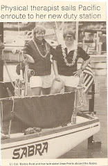
4. As a Lt. Colonel in the US Army, I had received orders to transfer from Hawaii to Washington. It was in July 1982, when I commanded my SS Sabra, a Sparkman Stephens designed, Swan 36, from Hawaii to Washington state and entered that infamous Strait of Juan de Fuca on 27 July 1982 0942 hrs. Just as the sailing instructions state, we were shrouded in a thick wall of fog stretching from Cape Flattery to Vancouver Island.  On foggy days, it is easy to understand how a ship sailing this coastline could, indeed miss the 12 nm entrance. My Loran, beeped, after 21 days at sea, informing us we were abeam and 2 nm offshore of Cape Flattery. We could barely see the bow of our boat. Yet, we confidently and steadfastly, held our course, and it took another 30 minutes of motoring to penetrate the windless, fog bank and emerge north and west of Neah Bay into bright blues skies and waters, where the majestic snow capped Olympic Mountains peaked far above the dark green forests of Douglas Fir. It was a sight to behold and is so clear in my mind’s eye today, some 30 years later. See blog Mar2012.
Fog at Strait of Juan de Fuca
Google Images

Loran Way Point at Strait.


I post this information to share how my personal maritime record, while small in comparison, does in fact, dove-tail with the northwest and transpacific travels of  Captains Cook, Vancouver, Gray and Lt. Puget. My ancestors have a greater competitive edge with  18 of my Dutch and French Huguenot- 9th great grand parents, who sailed the oceans of the world as early as 1623 to settle Dutch colonies in Nieuw  Amsterdam (Manhattan, New York),the Caribbean and South America. My Scottish ancestors rounded the horn, sailed to the Sandwich Islands, crossed the Columbia River bar and became the first coal-miners on Vancouver Island, British Columbia, the first settlers in newly formed state of Wisconsin, via the Atlantic, the Hudson, the Erie Canal and the Great Lakes and others had sailed the Atlantic, the Mediterranean, and the Arabian Sea landing in numerous ports of call in India, Mesopotamia and Egypt.


For 300 years my family lineages have been involved in Atlantic and Pacific maritime crossings: Some family names include de Forest, du Trieux, de la Montagne, Andriessen Bradt, de Hooges, Van Schoonhoven, Swartwout, Vermilyea, Van Pelt, Van Huyse, Broucard, Hendershot, Ozmun, Reid, Gilmour, Hewitt and  Dunsmuir.

Exploring and sailing is in both, my maternal and paternal blood lines and I feel that nautical bloodline course through my veins when I read about all their great adventures or step foot aboard a vessel. It is for this reason, I love to slip the dock lines from Shatoosh’s cleats and replicate the adventures of these great men and their ships. These knowingly planned and sometimes spontaneous, unknown replications are the “meat and potatoes” of my blog, which, after being birthed in 2008, has a worldwide following. I am always amazed that this has happened.


Tuesday, May 29, 2012

3. A Unique Encounter in the High Seas

The HMS Discovery and Chatham had anchored near Destruction Island on 27 April 1792. At dawn they weighed anchors and proceeded north along the Washington coast with great hope they would be finding the Strait of Juan de Fuca. The north western coasts were Captain Gray’s territory and he was suspicious of any known vessels in the area that would infringe upon his trade. The beaver/otter were as good as gold and he didn’t want to share one beaver with anyone, except for buyers of the highly demanded pelts in the Orient, Great Britain and Europe. Every man in Europe wanted a beaver skin hat. Captain Gray sailed out of Boston, Massachusetts  and was the Commander of the American ship, Columbia Rediviva. In a  few weeks he would discover the mouth of the Columbia River.
Paintings by Steve Mayo-Google Images
The Famous Encounter of 3 Ships.


On 28 April 1792, a lookout on the Discovery sees a ship entering from the north west and is on a converging course. They had been sailing the high seas for a year now, and it was their first sighted sailing vessel in 8 months. Upon approach it was recognized as the trading ship, the Columbia Rediviva with her famous American Commander Captain Gray. He had fought hard in the American Revolution on a Naval vessel, and was not happy to see British ships in this area. Captain Gray ordered a shot fired and all ships hove to.  Vancouver gave the order for Lt Peter Puget and  Mr. Archibald  Menzies, the Scottish botanist/surgeon to go in the launch and speak with Captain Gray, in order to confirm/find the great Strait of Juan de Fuca, which hopefully would then link them to the Northwest Passage. Menzies stated in his journal they had found it extremely interesting to have run across the Boston sea captain at the exact time in which they needed to confirm the position of the illusive strait.

Myth had just joined forces with coincidence and the mariners, cautiously, shook hands. During their 2 hour conversation Captain Gray was astonished to learn, for the first time, from the HMS Discovery envoy, a British mariner, Captain John Mears, had given him credit for sailing 20 leagues(1 league equals 3 miles) into the strait and made claims the American Captain had circumnavigated Vancouver Island. Captain Gray stated that upon going 17 leagues into the Strait(west of Port Angeles) he then exited. He, also, stated in the northern Queen Charlotte Islands( Haida Gwaii) indians had killed some of his crew and in fact, had held the Lady Washington captive for several hours. The Lady Washington was the first ship to fly the American flag, when she plied the waters of the northwest following the Revolutionary War with England. This maritime meeting of 3 great ships and their Commanders had clarified the nautical myths and calmed the waters of uncertainty. 

Captain Vancouver continued to take the HMS Discovery/Chatham north along the remainder of the Washington coast and in a short time they entered the Strait of Juan de Fuca. For 50 years the British Government had offered  military and civilian vessels a 20,000 pound reward for discovering a north west passage. This was big business and Vancouver wanted to succeed and so did every man onboard. They have  been at sea for a year and their primary mission was about to begin. 

Immediately, they began the exploration of the first Indian village between Neah Bay and Cape Flattery, which Captain Vancouver called, Classet.  As a precautionary and somewhat suspicious measure, Captain Gray decided to alter his course and followed the vessels into the Strait of Juan de Fuca to make certain that these Naval Ships, were in fact, exploring and not, infringing upon his fur trading  business. He was satisfied after a day and proceeded to follow his original course south along the coast and claim fame when he discovers and gains entrance to the Columbia River.

As the British ships plied the waters eastward into the deeper reaches of the Strait they made 16 anchorages  and explored villages, took sights, soundings, and drew charts. At the junction of the Straits and the southern and northern waters, Captain Vancouver sent the HMS Chatham north to explore the San Juan Islands and he turned south and entered what is now Admiralty Inlet, and named Port Townsend after the Marquis Townshend. They now have penetrated further into these waters than any other white man and the Indians they met were seeing white men for their first time in their lives. Would they be friendly or hostile?

They were in uncharted waters and became the first map makers of this portion of the Salish Sea. As you look out from the bow of your own boat, in this area, you are confronted with numerous land masses and inlets. Captain Vancouver orchestrated an unbelievable exploration of every major inlet in the southern waters and after the HMS Chatham did the same in the northern waters the two vessels rendezvoused at Restoration Point, on Bainbridge Island, and continued exploring southern waters until the return of Lt Puget and company on 27 May 1792.

2.In The Wake of Lt. Peter Puget: Keeping the Continental Shore to Starboard


In The Wake of  Lt. Peter Puget: 
Keeping the Continental Shore to Starboard
June 2012
by
Barbara Cullen Reid (Hira), USA Retired, LTC.
Commander of the 40 year old MV Shatoosh, Albin 25, HN 1124 
Built in Kristinehamn, Sweden in 1972 and 
Pashmina 2-1996 Porta-Bote
and
Consort Vessel, MV Skol 2, 2003 Arima Sea Chaser 16
Commanded by John Elmore, alias, Too Tall Tom

220 years ago, in 1792, an historic event took place in the Pacific Northwest corner of the  United States of America. The British Captain George Vancouver, Captain of HMS Discovery and Lt. and Commander William Broughton of the consort ship, HMS Chatham, entered the Strait of Juan de Fuca and began their epic exploration of the waters of the majestic Salish Sea searching for the illusive Northwest Passage which would connect the Atlantic and Pacific Oceans.
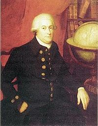
Captain George Vancouver
HMS Discovery


Stefan Freelan
Graphic designer WWU


“The HMS Discovery was of 337 tonnage, a Sloop of War with a deck length of 96 feet, beam of 27 feet, draft of 15 feet, and carried guns: ten 4-pounders and ten swivels. Muster roles accounted for 100 men ages 16 - 38 years old. She carried several smaller vessels that would assist the crew in exploring the continental shoreline with a greater intimacy and accuracy." Peter Puget, Newell and Wing
Model of the HMS Discovery


A large scale model of Captain George Vancouver’s ship of exploration, HMS Discovery, from which Lt. Peter Puget led the survey crews whose charts put the Northwest on the maps of the world. The Discovery model, commissioned by Discovery Modelers Education Center in Seattle, currently is on loan for display at the Foss Waterway Seaport Museum in Tacoma, Washington. Permission to use photo granted by: The Discovery Modelers Education Center, 860 Terry Ave. N, Seattle WA 98109. 206-282-0985


"Since the killing of Captain Cook in Hawaii, Britain ordered ships exploring in remote parts of the world to travel in tandem. Thus, the HMS Chatham became the consort vessel of the HMS Discovery and was of 135 tonnage, an Armed Tender, brigantine rigged with a deck length of 65 feet, beam of 21.5 feet and carried guns: four 3-pounders and six swivels. Muster roles revealed  45 men ages 17-45” Peter Puget, Wing and Newell
Lt William Broughton


HMS Chatham


Life at sea was not easy; the ships were over crowded and odoriferous, the teen aged able bodied  seamen were over worked, underfed, often punished when they disobeyed the rules by flogging using a cat of nine tails. They slept in swinging hammocks with 18inches of space and Captain Vancouver, age 33, was known for his fierce anger and difficult demeanor.


Both ships of His Majesty, King George III’s  Royal Navy had started their journey from England on 1 April 1791, sailing south around the Cape of Good Hope, New Holland(Australia), New Zealand, through the South Pacific islands, the Sandwich Isles (Hawaii) and in March 1792 they set sail for the west coast, known to the British Maritime as New Albion, but, to us and more specific, the coastal waters of Mendocino Point, California . They followed the coastline north, “keeping the continental shore to starboard” and needed information about finding and entering the Strait of Juan de Fuca. 

The Strait of Juan de Fuca had even been illusive to Captain Cook. It is interesting to note that the young 13 year old George Vancouver sailed with Captain Cook when they could not find the Strait. Now at age 33 he is about to make another attempt at finding this illusive strait. Maritime information held that Captain Robert Gray, aboard the Lady Washington had sailed about 20 miles up the Strait the previous summer during some of his trading expeditions. Could this be true or was it just another myth? Truth was as confusing as the seas were in this region of the world. No one had ventured deep into southern portions of this vast waterway and in fact, few had ever found the entrance to the Strait of Juan de Fuca since the Spanish claimed they did in 1592. Was it all just a myth?  Even today, as I research the history, there are many misconceptions in the writings, therefore, it is no wonder in 1792, their uncertainty was well justified. Juan de Fuca was actually, a Greek who sailed under the Spanish flag and used the alias name, Juan de Fuca. I’m glad it became the Strait of Juan de Fuca, because it would have become the Strait of Apostolos Valerianos and no one would have been able pronounce it!

Photos by Google Images and Wikipedia
The Salish Sea: permission Stefan Freelan


Monday, May 28, 2012

1.A New Adventure Begins to Take Form

About 4 years ago, while house sitting on Orcas Island, I happened to see a book with a detailed accounting of Peter Puget’s Exploration of the Sound by  Robert Wing and Gordon Newell.
Google images


 It was named, Peter Puget and I read it from cover to cover, thinking how much fun it would be to replicate this journey, once I got Shatoosh to the Puget Sound. I was a long way from getting Shatoosh to the Sound. I still had to cruise the Snake and Middle Columbia Rivers, go through 8 Locks and Dams and figure out if it would be feasible and smart to cross the Columbia River Bar and cruise a 25 ft boat up the Washington coast, which at times, can not be a friendly place due to the extreme weather conditions. Well, if you are a long time faceless blog reader, you know all that happened and without incident. Last summer, as I was making my way south  from my coastal cruise I continued to talk and think about this possibility and after my first docking in Gig Harbor, I headed to an old used book store and found  the book, buying it right away. Since that time, I have read it again, several times over, and stopped at several places to investigate possible landing sites in Pashmina and anchoring sites in Shatoosh.


As I write this, it is  February and the winds are howling outside my sweet abode, causing a large tree to fall blocking the back gate to the property. I am snug inside compiling information, typing up lots of notes and putting together a planner.


This will be one of my more simpler adventures. I talk often to my buddy, Too Tall Tom, who is an avid explorer/history buff and I am hoping he will take the challenge to join me, either on Shatoosh or with his little Skol, a 16 ft Arima, as a consort vessel.. Too Tall Tom is responsible for trailering Shatoosh to the Columbia River for me. This guy is always fun and funny to have on board. See Snake River blog  June 2010. 


28 May 2012: Memorial Day

Too Tall Tom and Skol are making there way up I-5corridor  from California to join Shatoosh, Pashmina and Hira and weather permitting in June we will begin our  Replication of Lt. Peter Puget's Exploration of the Southern Waters of Puget Sound.  I will be posting numerous sections of the history of these great Explorations prior to our departure. Read along and learn about this epic adventure that Captain George Vancouver orchestrated in 1792.

It is fitting that we celebrate today's posting in their honor as being British Naval Officers, as Too Tall and Hira being veterans of the US Army and to celebrate all those who have served and died in the military. My hopes of posting this adventure on the blog is that our awareness will increase about the Voyage of the Discovery and the Chatham, that as a result of this new information we will continue to cruise these waters with increased awareness, honor these great explorers and be extremely grateful for the hardships they endured as they ventured into the unknown.

We are about to have a great adventure so stay tuned and I hope you enjoy this one as we are about to have some fun.

References used in preparing all of the upcoming postings:

1. With Vancouver in Inland Washington Waters: Journals of 12 Crewmen,April- June 1792, Richard Blumenthal, also personal conversation 24 Feb 2012 in Bellevue Wa.
2. Peter Puget, Robert Wing/ Gordon Newell, 1979: authors deceased and publishing company no longer in existence.
3. The Interwoven Lives of George Vancouver, Archibal Menzies, Joseph Whidbey, and Peter Puget: The Vancouver Voyage of 1791-1795, John Naish, 1979
4. Peter Puget on Puget's Sound, Murray Morgan 1979
5. Sailing with Vancouver, Sam McKinney: author deceased
6. Google Images with special reference to Steve Mayo's artwork regarding the Discovery/Chatham/ Columbia Rediviva. While I emailed Steve Mayo for permission I never got a reply. Since the images were on Google Images, I took liberty to use them. I apologize for any infractions.
7. A large scale model of Captain George Vancouver’s ship of exploration, HMS Discovery, from which Lt. Peter Puget led the survey crews whose charts put the Northwest on the maps of the world. The Discovery model, commissioned by Discovery Modelers Education Center in Seattle, currently is on loan for display at the Foss Waterway Seaport Museum in Tacoma, Washington. Permission to use photo granted by: The Discovery Modelers Education Center, 860 Terry Ave. N, Seattle WA 98109. 206-282-0985 
8. Vancouver's journals online-google.
9. Wikipedia.com
10.Google Images
11. The Salish Sea by Stefan Freelan

Linda Joins Us

25 May 2012
Linda joins me in the afternoon for a short over night trip to McMicken Island, as she has never been. We have a late start for the Memorial Weekend and are surprised to see about 12 boats moored and anchored. There is a minus .97 ft tide when we arrive. So we anchor behind the great tombola spit that connects McMicken to Harstene Island. We choose to anchor closer to Harstene to get away from the crowds. This is giving me a taste what summer is like here. I have been spoiled to be the only boat here all winter and spring. But it is an opportunity to anchor and see how the holding ground is.

We take Pashmina ashore and walk the spit. We see lots of live sand dollars and even see sand collars which are made of thousands of moon snail eggs encrusted in sand. They are rubber in texture. I forgot my camera so here is a wikipedia explanation .http://en.wikipedia.org/wiki/Sand_collar


Linda is quite the farmer so she supplies new lettuce from her garden and we have fresh corn and jalepeno grilled shrimp and rice.


The next morning we take a walk through the trees.


This one is big..a douglas fir.

The weather is holding so we decide to stay another day. I want Linda to see Jarrell's cove. I figure it will be totally crowded, but we are surprised to see very few boats here. I pick up my favorite buoy at the rear of the dock area.


At low tide, a minus.3 ft still gives me 5 feet of water or 3.5 ft under the keel.
A young kid in a dinghy makes a nice trail in the water behind Shatoosh. We have a leisurely afternoon.


I take Pashmina over to the fuel dock/marina and look at boats. I get an ice cream for me and take a candy bar back to Linda. On my way back I cross paths with a Sam Devlin designed boat that I had seen at Hope Island. We got invited on board and she is a beauty. Again I did not have my camera. She is the MV Ellie K
http://store.devlinboat.com/kokanee38.aspx

27 May 2012
It is overcast, so Linda takes the snap shackle off the buoy and we head back to the marina about 12 nm away. What a nice, easy laid backed  trip and it is always fun to have Linda on board.

Sunday, May 20, 2012

Hope Island/ Squaxin Island to Home Port.

15 May 2012 Tues
Its 1230 hrs when I depart Hope Island and the Voyaging Society and I still am not ready to head directly back to my home port, so I continue to explore some more of the Squaxin Island shoreline. I anchor on the north side in a small cove and use my small danforth lunch anchor off the stern. The tide is ebbing, but the flow where I am anchored is gentle and I hold my position until 1430 hrs. I weigh my little anchor and for a change take it out on the bow rather than getting my cockpit wet. I find that it piggy backs well on top of my big danforth which is on the anchor roller.


This short trip has allowed me to see some new territory. Too Tall Tom is making his way to the Pacific Northwest. He has picked up Skol, his famous Snake River Arima 16 footer and will be arriving here next month. Stay tuned, as our big Peter Puget Exploration is about to begin and boy oh boy are we going to have some fun.
Day's run: 9nm
Total: 59nm.

A Surprise Encounter with the Puget Sound Voyaging Society

On the afternoon of the 14th and the morning of the 15th of May I am delightfully surprised by 2 visions of ancient voyaging. Off in the distance I hear a cadence being called, I get out of my comfortable position in the cockpit seat. Coming rapidly down on Shatoosh is a sight fitting for, "Oh my God". Since I spent the greater part of the winter planning for my upcoming Replication of Peter Puget's Exploration of the Puget Sound, here is an almost replica of one of his longboats rowing the southern Sound. I scramble for my cameras and try to get something down. Then the next day I run across them on the other side of the island and get to find out who these unique group of young people are. They belong to the Puget Sound Voyaging Society out of the Port Hadlock/Townsend area on the Olympic Peninsula and they are on their annual week long cruise sail+row. Some are sleeping on shore and some in the boat. I get to speak with Sam, Shawn and Jacob and learn about their program for boating and building skills. This rowing/ sailboat is  larger than what Puget used and there are 4 pair of oarsmen and 2 other crew.
Sam and Jacob

Shawn rows supplies to shore


Take a look at what these kids are doing. I love it and hope to see them again on the Sound. Sam, I love your singing video as well.
http://communityboats.wordpress.com/


Hope Island to Boston Harbor

14 May 2012 Monday
Departure is at 1030 hrs and I head eastward out of Squaxin Passage and across Dana Passage to Boston Harbor which has a little store, fuel dock and marina. They have diesel, however I had to wait forever for someone to come down to the fuel dock as there was some communication problem so I fill up and then go around to the guest dock to pick up some supplies. They are out of all their seafood, their docks are pretty bad and broken up which makes for unsafe walking, but the help are friendly and apologetic for making me wait at the fuel dock. This is historically a quaint place and I will re-visit it in the future. I didn't even take a photograph but here is my course.


Day's run: 9nm
Total: 50nm

Thursday, May 17, 2012

Hanging Out On Hope

13 May 2012: Mother's Day
What a day! My serenity tank is full, everyone passing by in kayaks are greeting me with Happy Mother's Day. This is a happy day for all mothers and mothers are always filled with Hope.  What better place to be, but on Hope Island, especially after days of stretching and reaching on those islands it makes room for hope to seep into all the new cracks and crevices of our being.

Across the way is Squaxin Island, an Indian Island and no one can  come ashore. There is a large inlet named Palela Bay, near Potlatch Point. A sailboat is anchored at the entrance. I gather all my exploring items, water, binocs, waterproof container with a few tools, sunscreen, camera, some nibbles and I am off in Pashmina.
I am anchored at red dot and my course is the red one.
The blue line is from yesterday.
The red circle is a buoy that I tie up to later in the day.


I am in the lagoon looking out toward Hope Island, the sailboat is anchored and the tiny white speck across the way is Shatoosh. I come across a derelict boat tied to shore( there seems to be many of these). There are many old fishing nets lying on the bottom with years of growth on them. The bottom photo is the thumb part of the lagoon as it looks like a mitten on the chart. The tide is ebbing and the water tables barely allow me to skim over the bar and out. I stop and talk with the sailor anchored and he shares info about this area and anchoring. He comes here often.


Later in the afternoon a buoy opens up and I grab it.  At 1700 hrs, I reboard Pashmina and circumnavigate the island, stopping from time to time to walk on the beach. I return at 1850hrs. and fix dinner. I'm seeing lots of raccoons, eagles, kayakers and seals. In fact one popped up behind Pashmina about 10 feet away and startled both of us.
Mt Rainier in the distance


A great Douglas Fir Tree


It is tall as can be


A gnarly mess of wood 

Shatoosh on her mooring buoy awaits our return.


Lots of raccoons on the island. I have seen as many as 7
feeding at the  shoreline in the morning hours.


What a wonderful day. Hope Island is delightful. I had been here once before on a rainy, cold May day on a friend's boat, but I am loving it today.

A Day of Exploration: McLane Cove/Stretch/Hope

Being tucked in Jarrell's Cove and tied to a dock for the night, I never once heard the north wind howling. I don't think it did. This is a wonderful state park and a favorite of many boaters. Again, I have it all to myself and take a leisurely morning watching the swallows flit back and forth to their houses on pilings, the Great Blue Heron taking note of all activity and the kingfishers chattering away. Its 1030 hrs and I slowly move from the main dock to the pump out dock at the entrance. This has got to be the most efficient pump out that I have ever used. Impressive, indeed.


I'm off headed back up Pickering Passage to check out some areas I noted in traveling down yesterday and from previous passages through these waters. My first stop is McLane Cove. The chart shows a nice indentation with room to dinghy under a bridge. There are several boats on private mooring buoys as housing is along all of the shoreline. The tide was ebbing and I  decided to save  anchoring here for another trip. I move on over to the big, unnamed bay between Stretch Island and the mainland.
This one had been sunk and tied to a tree


I anchor easily in 24 feet of water and spot a lagoon behind a large beach. It seems to extend quite a bit farther, so this is my cue to do some rowing. The water is crystal clear and we slip into a nice well hidden salt water lagoon which provides a perfect swimming area for the homes on the hill. I turn Pashmina to starboard and continue down a long inlet. The oysters in the muddy bottom are longer than my hand and there are plenty of them here. 5 Hooded mergansers take flight and I see several raccoons along the shoreline. It is a lovely little ecosystem and I continue to row until Pashmina scrapes bottom at 4 inches of water.
Impressive Stone
A rock erratic from a pliestocene glacier


Entrance area off lagoon


I take a right hand turn around this sand point and am in the lagoon


The inner lagoon

Barnacle and Shell encrusted tree limbs


This peaceful lagoon touched my heart and by the time I had rowed down and back, I was moved to tears of joy bubbling up inside me. Nature really touches my heart, everything is in order; the sweet, innocent raccoons know how and when to dig for their food, the mergansers have nurtured their new family and oysters are growing in this safe haven. I wanted to leave it just as I found it, so life could go on forever.

1740 hrs I have made my way down Pickering Passage to Hope Island, which is a small state park with 5 buoys. I circle the island checking it out, only to find all the buoys taken. I anchor on the northwest side in 20 ft of water and savor the sunset.


Day's run: 17nm
Total: 40nm