Sunday, November 9, 2008

Fall Comes to Scappoose

10 November 2008
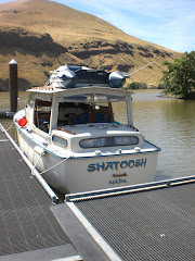
I made a quick trip to Shatoosh today to take care of some pre winter care; pumping out the fresh water tank, hooking up the cockpit dehumidifier, closing seacocks, and stowing items and organizing books.

The drive down was spectacular, breath taking vistas of the fall colors coming to a close, lots of migratory birds, Canada Geese and Sandhill Cranes filling the skies as they descend on Sauvie Island. It literally stops one in their tracks, as the skies are filled with hundreds of v-shaped flocks criss crossing overhead. The noise of their calls, deafening, as I meandered over to have brunch at Marks on the River which is a floating restaurant at my old marina, McCuddys on the Multnomah Channel.

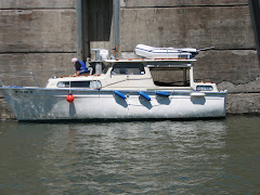
I took some shots on my cell phone of some interesting boats along the way. Thought you might like to see some cutey pies.


This is called (.calm) and is a new vessel in Scappoose Moorage. It is about 25 ft. I love the name and the dot is painted in bright blue. Get it?


A really nice Fisher 25. Fisher is made in England and if I were ever to get back into sailboats I would get a Fisher 30.


This is Mis-Adventures a very nicely refurbished Tolley Craft.


A nice looking Arima 21 ft.

Monday, November 3, 2008

Care Joins Me For Beacon Rock Cruise 2004


Beacon Rock Cruise16-21 June 2004

16 June 2004 Wed: We depart Scappoose moorage at 1200hrs, after a nice morning drive down and preparing the boat for travel. The skies are blue and no clouds in sight. Soon after heading upriver on the Multnomah channel Care spots an eagle landing in a tree and soon discovers a huge nest in a large cottonwood tree. Its a pretty spectacular sight. This trip will be fun with Care’s exceptional knowledge of birds. We cruise by all the floating homes and turn down the Willamette River at 1345. By 1410 we are on the Columbia heading east with lots of current coming down river. We pass numerous ships through Portland’s harbor all from various foreign ports and all anchored waiting for loading. Several tug and barge combinations pass up and down river.


We slug our way up river with the swift spring run-off slowing down to under 5 knots and finally reach the new docks at Barlett’s Landing on Government Island at 1700 hrs. Lewis and Clark named this island Diamond island because of its shape. While we can go ashore to the toilets and camping areas we cannot venture onto the island. History tells us the island is now named for the government growing hay for the horses housed at Ft Vancouver. The new docks are really nice and the current flows pretty fast through the whole place. We meet some other boaters and find out more local knowledge of the areas we plan to explore. One boat is a unique Californian 30 with a 6 cyl Cat Diesel owned by a lady with her husband. She is the Captain. He tells stories of the glacier history of the Columbia.
Day’s run 24 nm

Bartlett's Landing to Beacon Rock


17 June Thur: Dawn is coming quite early, but we meander through coffee and breakfast leaving Barlett’s at 0830. This next phase is picking up the numerous range markers for the barge channel. There are numerous islands and shoals through this area so a close navigational eye is in need. We are now getting accustomed to the numerous osprey nests on all the channel markers. All the mothers are sitting patiently awaiting their broods to arrive. About 0930 we pull into Washougal WA. to get fuel at the local marina. Departing at 1000 we fall in behind a tug and barge and pick up the channel again. Soon the tug is long out of sight and the wind begins to pick up on our nose. Now this is not what the books say; “In the summer months beware of strong upriver winds building late in the afternoon.”


Our next area to explore is the Rooster Rock State Park. This area has a huge conical peak, once known as Cock Rock, but later changed to its present name. The entrance is a narrow slough and the chart doesn’t even show there is evidence of a marina. Folks back at Bartlett confirm it has adequate depths this time of the year. But later in the summer it shallows to about 4 feet, preventing many boats from entering. Care thinks it might be good to stop and have lunch, so we look and look for its narrow entrance and slowly enter the small slough. It winds around the shore line and Rooster Rock. We come upon several short docks and a large long one which is not attached to shore. We choose the first one and the wind and current are tricky so I end up being blown away from the dock and on the second try I succeed with the agility of Care handling the dock lines. We venture ashore, checking out toilets, trash cans and showers. Only one bathroom is open and without shower. We fix a nice lunch and are on our way by 1240 after arriving at 1130. The depths turn out to be 5 ½ to 8 ¾ feet. We have gone a total of 35.3NM so far.


This is the beginning of the famous Columbia Gorge and the views upcoming are rather spectacular. High canyon walls filled with water falls, evergreens and the silhouettes of many canyons fill our visions. The headwinds are picking up and ahead are a variety of kite surfers criss-crossing the gorge and some coming quite close to the boat. We are approaching the WA Side of Cape Horn and a down river barge is also converging on us. So now we have the winds, surfers and barges and us, all going in different directions. Cape Horn, was named by Lewis And Clark, as they descended the Columbia in Oct 1805 were met with head winds coming upriver. Just like the book describes. We are re-reading and referring to Steven Ambrose’s Book, The Ultimate Courage, about the Corps of Discovery and its journey across America, departing St. Louis in May 1804 and returning 1806. I have several brochures which ear mark the camps with their dates. I share with Care what it must have been like to be the first white men/negro man to have journeyed this particular strip of landscape. Cape Horn is a spectacular cliff with waterfalls, pinnacle and columnar granite at the base. They plummet to the water’s edge. I recall those incredible columnar granite stacks on the Salmon River Raft trip that Care invited me to go on a few years ago.

Off in the distance the towering Beacon /Rock looms with a height of 848 feet, our destination for the day. The winds are quite blustery and the waves force us to turn on the wiper. We criss cross numerous fishing boats anchored for some late salmon and the prehistoric sturgeon. The currents are picking up by the mile as we get close to Bonneville dam. I’m told that they can get up to 8 knots. Our speed is down to low 4’s and occasional high 3’s. We have an upcoming barge on our stern as we find the entrance to the Beacon Rock State park and marina. There is another boat docked on the outside with the current pinning him to the dock, so I choose to go inside and try to dock on the port side which is a mistake and I can’t even get near the dock so with the wind, current and a quick decision we spin around trying hard to keep from blowing onto the shore and tie up on starboard. The current is fierce in here and Care and I struggle to pull the boat next to the dock. It is 1530 hrs and we have traveled a total of 47.6NM. We begin to settle in and enjoy the view of Beacon Rock. I say to Care, “do you see what I see”. I am looking at the intricate switch backs staircase snaking its way up the rock. I wonder if I am up to climbing it. We hike up the road quite a ways and someone tells us we have to go onto the main highway and walk half again as far to get to the trailhead. We decide that we will try in the morning when it is cool. We notice a sign for ice, which we will get tomorrow. Later in the evening, it cools off and the wind stops blowing and we enjoy a still night. Care sees a mother Merganser swimming with her babies on her back. She has heard of this happening and a first for her to see this. There are 4 babies. What a sight. My first to see merganser babies.

Climbing Beacon Rock


18 June Fri: We depart via foot 0850, the winds have returned early in the morning again from the north west and by the time we get to the ranger station for directions and it is blowing so hard we can hardly stand upright. Our caps go into our packs. It must be gusting 30 knots. We see a sign on the base of the mountain about a man who purchased the Rock in the early 1900’s and around 1917 he and friends built the staircase in 3 years. It is almost a mile in length, and has a railing and different flooring, some rock, some cement/rock and some wooden planks. There are numerous switch backs and the views are circumferential up and down the gorge. Shatoosh looks like an ant from the top. A coast guard chopper zooms the top headed up river and a sea plane heads down river. A train on the Washington side winds its way below and we loose sight of it in the forest. We see 2 leaves blowing upwards in the up currents, and the ospreys, vultures soar in the updrafts, while the chickadees chirp their hearts out in the lower portions of the forest. The falls across on the Or. side can be seen through binocs. We have hiked slowly and savored each switchback. Who knows if we will ever be back to hike this peak again.


I can’t help thinking of Lewis and Clark. The day as they entered this gorge after leaving the high desert areas of the Snake, they thought this was a sight to behold. Thousands of geese, deer and elk roamed the hills. If it weren’t for the food in the frig I don’t think Care and I would have eaten much if we had to rely on hunting today. We head back and try to find the ice lady who states, they are almost out, so we take 2-10 lb bags of chipped ice and continue hiking back to the boat It is hot and the ice is heavy but we arrive at 1230 and a total trip of about 5 miles.


We shower and have lunch and laze around reading, watching all the little boat fisherman with a few catches of salmon and sturgeon. Evening Care spots another Merganser family with 8 older babies. They nestle down for the night on a log boom at the entrance to the dock area. Several dock fisherman appear, one is from Russia and catches 2 small sturgeon. Someone said they had caught an 8 footer off the dock recently. Well, that would be something to see. Another spends the afternoon and night fishing for squaw fish as they have a bounty on them at $6.00/fish. They destroy the natural habitat of fish and many people make their livings by fishing for squaw fish.

Beacon Rock to Rooster Rock


19 June Sat: I decided with the arrival of early morning wind, we should depart early and try to see if we can get up to the dam, check it out and then return for breakfast. So we depart at 0630 heading out of the cove and into a windless wall of current. We start out at 4 knots then gradually dwindle to 1.3 knots and not making any headway. I abort the plan and upon turning around we are clicking along at 12 knots. We return to the dock and I fix breakfast. At 0925 we depart Beacon Rock again and head east to Rooster Rock with an ETA 1110. We pull in and get our spot, there are no boats. Later as the day passed many people came to the park to fish, canoe, swim, water ski and Care and I took another day of reading, napping and putting my Oregon stickers on the boat. Now I am legal on both sides of the boat. We had put the starboard numbers on while docked at Bartlett landing. The wind never came up that day. Everyone left and we had the cove to ourselves with one other boat on the floating pier.
Total miles: 61.7NM.

Rooster Rock to Coon Island Via the Gilbert River

20 June Sun: Father’s Day. I think of my father, Bob and talk often to Care about all the boating and fishing we did as kids and am grateful to have had parents who taught us about fishing and boats. We shoved off from Rooster Rock on a windless morning at 0845 going 9 knots down river zipping past all those places we had been, no headwinds, just engine and current. It is effortless. We had lunch onboard, continue down the Columbia River all the way to St. Helens, arriving at 1315 with a marina full of boats. We jockey for pump-out positions and soon we are pee free and on our way up the Multnomah Channel headed for Gilbert River. I had heard from a local that it is possible to take my boat all the way up to the mouth of Sturgeon Lake which is on Sauvie island. In the winter this is a refuge area to thousands of Canada Geese and my favorite, Sandhill Cranes, and is off limits to boating. I decide to go for it and we are surprised to find the river widening as we go up it. I was told that it gets very narrow, but the erosion of many wakes over the years has cut away the bank increasing its width. The depth ranged from 9 to 32 feet at the 90 bend by the fishing dock. We kept a close look out for dead heads and jet boats. It looked like the Georgiana Slough. We saw the lake and turned around at 6 knots and got back to the Gilbert river dock at 1615 and were docked in the shade of the east side of Coon island at 1640. After dinner and near sunset Care and I went for a loop trail on the south side and in the darkened canopy of cottonwoods we ran into an Owl sitting on a limb. Care stopped as it was about 10 feet away. Out of the corner of my eye only feet away was another staring at us with its yellow eyes. Then a third one fluttered above us. We figured one was baby and the others were its parents. We got to watch them for some time and then we scurried back to the boat to get the bird books and discovered we had found Screech owls. What a find. This was all new for me. We had time to examine them as they never flew away. What a picture I will carry in my mind’s eye.


Total 113nm

Coon Island to Scappoose Moorage

21 June Mon: We depart Coon Island at 0905 and arrive at Scappoose Moorage 0945. We finish cleaning up the boat and head for home in Tacoma. We pass a woman and child on Hwy 30 near Deer Island and later see her car with hazard lights on. Because of the extreme heat and seeing this little girl walking on the highway is flimsy flip-flops, Care and I are concerned about their safety. We turn around and see if we can help. We take her to a filling station and by the time we get back to her car the battery is dead. We jump start her car and we are off again. She was unemployed and had coupons for gas. Her grand daughter had the most striking blue eyes I have ever seen. We hope they do well and she is able to find a job. She is from Rainer and there are no jobs in the community, so she has to go to other local towns to seek work.


Overall we saw over 40 different bird species; green herons, northern yellow throat, towhees, about 50 osprey nests and cruised 116NM and hiked 5 miles. It was a very wonderful cruise and Care adds so much with her bird knowledge and cribbage teaching in the evening hours. The meals were planned very well, the ice lasted and a great time was had by all. Climbing Beacon Rock, cruising the Gorge, seeing an eagle nest, merganser babies swimming on the mother’s back, and the owls were our favorite highlights. Also, a treat for me was going up the Gilbert River. I love exploring and having new adventures. That is what this blog is all about. Shatoosh and Pashmina smile, wiggling their bows in total agreement.