 |
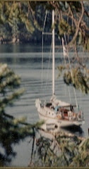
| sunset thru the trees at McMickin |
 |
| My position on McMickin using my Iphone Notice the tombolo and all the boats anchored on the north side of the island. |
I had a quiet night and fogged in by morning. I'm ready to go at 1000 hrs and as usual the sun breaks thru for me and I slip my buoy shackle free at 1005. I'm taking the long way around to Totten just so I can pump out again at Jarrell's Cove. I'm in and out in 10 minutes riding smooth as glass on a flood tide down Pickering passage at a nice 7.4k. A cloudless, windless morning with the tide pushing me along. What more could a ex-sailor girl ask for?
Ever since Too Tall and I made our Puget trip into Totten I have wanted to return. So today is the day, Saturday 11 August 2012. At noon I am entering Totten and make my way down to Little Skookum inlet. Skookum means "strong" and my intent is to anchor either in Wildcat Cove or Deer Harbor, both of which are shallow. Then if this looks good I will take Pashmina to explore the more shallow parts which are oyster farming.
 |
| Rock erratic Totten |
 |
| Little Skookum Inlet |

With the flooding tide I can actually penetrate the inlet in Shatoosh farther than I had thought. It is narrow and winding, but at 10 ft of water I retreat to perhaps anchor. I tried my lunch hook in both places but couldn't get a hold. I depart and head back out into Totten looking at several places to anchor and find a spot which looks, so I drop my lunch hook and it sets easily in mud. I am on the eastern shore in 20 feet of water which will work out nicely with a low tide water of 9 feet by morning. This is my kind of spot on the usual busy weekend. I am all alone, no boats, no people, just gulls, crows and seals. It is like a large lake about a half mile wide with a nice view of the Olympic Mtns off in the west.
I have mentioned this several times but worth stating again. I find it most helpful to scan new areas of exploration using google earth. I looked at Wildcat and Deer Harbor coves and the shorelines scanning for high bluffs, and areas without houses. Depending on when Google takes the photos, you can see deep water channels, mud flats, populated areas and on my iphone I can use the satellite image hooking up with my local position as I am cruising to pin point the deeper channel that may not be noted on the chart. Isn't technology wonderful?
Since it was so calm all day I made a rare choice for me: I stayed on my lunch hook all night. This is something I would never recommend,or do, but in these conditions it was perfect. At low tide this morning I had 9 feet under me.
Total run 27.1 nm


