My friends Joyce and Phyllis who recently bought Shatoosh,aka, Hobbit are in the process of starting their own blog to document their adventures. While they live in Arizona, they are in British Columbia getting some work done on Shatoosh for some summer and fall cruising.
The Blog is named The Continued Adventures of Shatoosh and the link is
shatooshmoveson.blogspot.com
At present their profile is up and soon coming will be their first posting. Stay tuned. Congratulations Joyce and Phyllis.
Sunday, June 10, 2018
Tuesday, June 5, 2018
Adrift, the new movie about Tami Oldham Ashcraft
I'm going to the movies this week to see Adrift, the new movie about Tami Oldham. She wrote the book, Red Sky in Mourning. A real life adventure of being pitch poled from a hurricane in the south pacific ocean, jury rigging her sailboat and sailing it to Hilo Hawaii. Her story is moving, tragic and a testimony for what it takes to survive the savage sea.
I met Tami in Friday Harbor the fall of 1987. She was looking to finally buy a sailboat after healing from this traumatic event in her life. She bought my Sabra, a Swan 36 and later sold it to a lady in Port Townsend. We've lost track of Sabra.
I'll let you know what I think about the movie. I hope the film makers do it justice as the last boating movie I saw was Robert Redford's All is Lost, and it was a failure.


P.S. I saw the movie and thought it was really great; the hurricane scenes were terrifying, the sailing and sunsets were beautiful and many of the true facts were presented. It was portrayed as though her fiance survived the hurricane but later suggested it was her hallucination. Much of this segment was given more time than showing what Tami did to survive on her own. The other scenes not were not authentic was her diving off the boat to spear mahi mahi fish. One would never dive off your vessel to fish. You'd throw off your fishing line.
In a interview with Tami, she loved the movie and was pleased to have it finally made. Her dream came true. She was asked about the segment of her fiance living and she said she talked with him every day and he answered her. It was as though he was still alive. She seemed pleased.
Congratulations, Tami on a job well done.
A New Boat for Hira
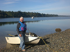
Last fall I moved back to Lakewood Washington to my old hang out on Lake Louise. I've lived there numerous times in my life and this quite little lake is a fun place to live and go fishing. This spring I found the perfect little fishing boat for me. It is a Viking Waylander, flat bottom 8 feet length and 4 feet beam. Not much to look at, Army green and easy to row. My first trip out I caught a beauty of a trout. Oh yes, I forgot to tell you they stock the lake. Life is good.


Wednesday, February 21, 2018
A New Twist of Ownership
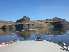
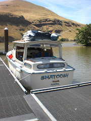
I have exciting news to report. It has been in the making for several months, but Shatoosh, my previous boat has been sold again and the new buyers are two of my friends Joyce and Phyllis from Arizona. Joyce who has crewed on Shatoosh while I had her in the Sacramento Delta, the Columbia River, the Pacific coastal waters of Washington, Puget Sound and British Columbia will confidently take the helm of Shatoosh. Phyllis is new to boating and excited to be part of a slow boat to everywhere.They are returning her to the name of Shatoosh. They will trailer her up to British Columbia in April and will begin cruising the Salish Sea. Perhaps Joyce and Phyllis will begin a new blog. I'm really happy Shatoosh is back in our circle of friends and know she is champing at her dock lines to start cruising again. Its great to know someone you like who owns a boat.
 |
| Phyllis on the Left, Joyce on the Right |
 |
| Departing Sacramento CA |
 |
| Shatoosh settled into her Arizona storage space |
Tuesday, December 20, 2016
Shatoosh>Hobbit Has Another New Owner


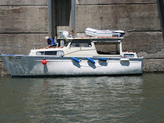
In November 2016, Shatoosh my old Albin 25, HN 1124 renamed Hobbit by Mike June was sold again to Mike Cady who lives along the Sacramento River in California. These photos show some of the extensive work Mike June had done on Shatoosh and the new owner Mike Cady launching her on the Sacramento River. Hobbit will be berthed at Courtland on the river. May the new owners have a wonderful time with my beloved Shatoosh/Hobbit/?. It is interesting after all those years and miles miles that she is back in California and in the Delta Region. She was originally shipped fro Sweden to San Francisco Bay.
Previous names for Hull Number 1124
Seahorse
High Life
RayAnna
Shatoosh
Hobbit.
Friday, April 29, 2016
Shatoosh Gets a New Name
Hobbit is her name. "We named her Hobbit because she is small, faithful and will take us on epic adventures". Mike and Donna June have been hard at work doing a re-do of Shatoosh. I'm just now getting some pictures. Their long awaited launch is upcoming and I'm hoping to get to see her at some point. I'm so excited for them and Hobbit. They hail out of Hood Canal so keep an eye out for her and introduce yourselves to them.


Wednesday, July 8, 2015
The End of an Era
Mike, the new owner came over to my condo yesterday and retrieved the last remaining odds and ends of Shatoosh and Pashmina. I gifted more of my personal books and put lots of items on his thumb drive. His granddaughters, Charlotte and Gabbie got their fair share of goodies.
It is so wonderful that they are already using the boats, crabbing and cruising. Mike will make sure that he brings Shatoosh up to another level of care which will give her a new lease on life. All of this makes me very happy.
In December 1999, I wrote on a small piece of paper. It said,"I want an older fiberglass diesel powered cruiser. One that I can run and jump on and go anywhere I want to at a moment's notice." The next day I found my boat and almost 15 years later, she fulfilled all my dreams and created many unsuspecting Adventures that were beyond my imagination.
There were so many crew, so many guests, so many faceless blog readers, so many mentors along the way that I could never list them all, but my heart is very grateful for all who planted seeds into the nooks and crannies of my my mind, for all who joined me along my routes and all that sat in their armchairs and read the blog. I thank you all for making the Adventures of Shatoosh and Pashmina a very fun and important time in my life. It was a fantastic run.

Since selling the boats, the blog continues work its miracles among Albin owners. I will let John Stokes in Georgia post his own story on his blog. John lost his tablet, another man found it and it had been run over by a vehicle, but there was enough life left in it for the man to see my blog and John's blog. I was able to give contact information and they all met for coffee, the dead tablet was returned and John has a new friend and the new friend will be getting a boat ride on Ms Bettencourt in the near future. Blogging is such fun when you own an Albin 25. If you don't have one you better buy one.
Subscribe to:
Posts (Atom)